Monday, December 28, 2009

Shoot! Score! Patagonia!


Patagonia Knifeblade pullover and the PatagoniaAlpine Guide pant.


The original Knifeblade pullover was made from Polartec® Power Shield PRO®. The Alpine Guide pants are made from Polartec® Power Shield®. Great pants for dh skiing.Love them! My current favorite down hill skiing pant. But not as water resistant/proof as the Power Shield PRO® fabric. The pull over Knifeblade top is one of my all time favorite climbing shells. Good warm weather ski shell as well.


If the video linked below is correct the newest Knifeblade jacket and pants are both unlined Polartec® Power Shield PRO®. Even better I think for skiing or nasty, wetweather climbing. Undecided yet on the climbing end. Not because of thePower Shield PRO® fabricmind you. It is amazing. The cuff design is what worries me. Although the insulated Northwall pants of Polartec® Power Shield PRO® have been good in really cold, wet weather for skiing. Too much faff in the cuff for me as a climbing pant. Too bad as the insulatedmaterial is perfect for cold weather climbing I think.


Certainly a good alternative to the few Neoshell options available. Very happy to see someone take advantage of the fabric is the right context and now in an insulated (if you can still find them as the NW pant/jacket has been discontinued) and uninsulated version.


The entire line of Patagonia alpine climbing clothing has take a huge step forward in materials and patterns the last two seasons. These two look to bump the bar higher yet. Bravo!


Not been a huge fan of Patagonia in the recent past. Had been a fan a few decades ago and they are back going gangbusters with their newest alpine clothing. It may not be the best in every category. But as a long time Arcteryx fan it took a lot to bring me back and get me into Patagonia clothing. And Patagonia hasindeed done very well across the board in the Alpine line from what I own and have used..


Patagonia Mixed Guide Hoody


Colin Haley's recent comments:


http://www.thecleanestline.com/colin-haley/


"My motivation is simple and selfish. Often the very best Patagonia alpine products are discontinued after only one year on the market because they don't sell well enough. This is why some pieces which are now a cherished staple, such as the RI Hoody, were once discontinued."


I have more Patagonia in my gear closet currently that is being used than any other brand by a fair margin. That says a lot to me.


The pieces I really like for anything from down hill skiing to backcountry skiing and ice/alpine climbing. Mix and match as required. It is quite a collection for the intended purposes. And I haven't used everything available just what is listed here.


Capilene 2

Micro D pullover

R1 hoody

Piton hoody

Nano Puff pullover

Knife blade pull over

Mixed Guide hoody

Mixed Guide pant

Alpine Guide Pant

Northwall Jacket

NorthWall Pant


(edit: I had incorrectly listed the pant I really like and use as a lot, as the BC Guide Pant. When in fact I have been skiing all winter in the Alpine Guide pant.... Sorry about the confusion and I have edited the original content to reflect the reality of the Alpine Guideinstead of what I had only imagined I was using ;) Thanks for the clarification and corrections Travis!)


The Patagonia Simple Guide garments have to be one of the best clothing deals on the market for what we all do.


The newest Knifeblade garments here:


and another new one I think will be a big hit, the Nano Puff Hybrid.


Sunday, December 27, 2009

Wordless Wednesday - One of the Joys of Summer!

August 1998. Digitized ...Copyright © 1998/.. by Rebeckah R. Wiseman

Camp Patriot Climb

The motto for Camp Patriot, “giving back to those that have given” effectively states their mission: to provide disabled veterans opportunities to continue enjoying outdoor adventures. In this spirit, three disabled veterans were chosen to join professional climbing guides on a summit climb of Mount Rainier, a challenge that many climbers without any physical obstacles find difficult.

The three participating climbers, Ryan Job, Chad Jukes and Joey Martinez, all served in the military and are disabled as a result of injuries sustained during a tour of duty oversees defending our country. Each was chosen because of their unwavering commitment to service, their strength, courage, and dedication to continue living active and fulfilling lives despite past injury. Camp Patriot commemorates these exceptional men and in the process provides this experience of a lifetime.
The attached photo was taken on the last day of Camp, Sunday July 10th, when two F15's from the 173rdFW out of Klamath Falls, OR, flew overhead Camp Muir at precisely 8:00 a.m. to celebrate this extraordinary climb. For more information about Camp Patriot and the Mount Rainier climb, see a recent front page article posted in the Seattle Times
or check their website.

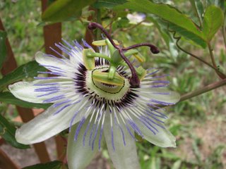
Passiflora caerulea


Blue crown passionvine in bloom in my garden during June.

Friday, December 25, 2009

The Huffman-Hoffman Kinexxion :: Heirs of Michael

The first document listing the heirs of Michael Hoffman was dated May 15, 1778 and was the Petition for Partition of the Real Estate.


Estate of Michael Hoffman

Berks County, Pennsylvania Probate Files

Family History Microfilm 1653590 Accessed February 11, ..

To the Honorable the Justice of the Peace of the County of Berks at an Orphan's holden at Reading the 15th day of May in the Year of our Lord 1778.


The petition of Martin Hoffman, eldest Son and Heir at Law of Michael Hoffman late of Alsace Township in said County Yeoman deceased.


Humbly Sheweth That your said Petitioners Father Michael Hoffman died the 6th Day of January Anno Dom. 1777. leaving a Widow, named Mary and twelve children, to wit. Your Petitioner aged thirty six Years, Dorothea Now the Wife of Henry Shedler of the Age of thirty Years, Burghard Hoffman of the Age of thirty three Years, Dietrich of the Age of Twenty seven Years, Christian of the age of twenty three Years, Elisabeth of the Age of Nineteen Years, Henry of the Age of Eighteen Years, Catherine of the Age of fifteen Years, Barbara of the Age of twelve Years, Michael of the Age of twelve ten years, John the age of six Years & Mary of the Age of four Years all thereabouts.


That the said petitioners Father died Intestate Seized in his Demise as of Fee of and in A certain messuage on Tenement and Tract or Parcel of two hundred Acres of Land Situate in Alsace Township aforesaid.


Your Petitioner therefore humbly prays your Honours would be pleased to award an Inquest to divide the Said Estate among the said Children, if the Same can so be, without prejudice to or Spoiling the same, and if not to Value and Appraize the said Real Estate of the said Decedent, Agreeable to the Directions of the Law in Such Case made and provided.


And your Petitioner as in duty bound will pray, Martin Hoffman

The next document, also dated May 15, 1778 was the Inquisition ordering the Sheriff to have an appraisal made of the land which Michael Hoffman owned. I'm not going to transcribe the entire thing here because it basically reiterates what was in the Petition for Partition listing the heirs. However, even though it still says there were twelve children, the name Philip is inserted after Martin's age and just before the name of Dorothea.


Top portion of a document in the probate file ordering the Sherriff to have an appraisal made of the land which Michael Hoffman owned.


On June 9, 1778 the real estate was appraised by “twelve free honest and lawful men” who found that the land could not be parted and divided among the children “without prejudice to or spoiling the whole thereof” and it was appraised at seven hundred pounds.


Petition of Maria Hoffman stating that there were 13 children of Michael Hoffman and requesting that guardians be named for the four minor children under the age of 14.


To the Honble the Justices of the orphans Court of Berks county held at Reading the 14th day of August 1778.


The petition of Maria Hoffman Administratrix of Michael Hoffman Late of the said County Yeoman Deceased


Honorably Showeth That the said Michael Hoffman Lately died Intestate leaving 13 Children and a Considerable Real & Personal Estate to and among whom the same does Descend.

That our Petitioner has administered to the said Estate as the Widow & Relict of sd Decd.

She therefore humbly prays your honour Would be pleased to appoint Some proper persons As Guardians to take care of the persons & Estates of the the Minor Children of the said Deceased, to wit, Barbara, Michael, John & Maria All under the age of fourteen years.


And your Petitioner Will over & pray.

Maria Hoffman {her mark}

The Orphan's Court Journal (v2 p248) shows that Jacob Lanciscus and Paul Feger were appointed Guardians of the four minor children under the age of fourteen. Also, guardians were appointed for the four minor children above the age of fourteen: Henry chose George Babb, Elisabeth chose Frederick Shleare, and Catherine chose Jacob Lanciscus.


On that same day (August 14, 1778) a document setting forth the amounts to be distributed to the heirs was filed (see below). However, the distribution wasn't actually made on that day. It seems that “Martin Hoffman Should hold & Enjoy the Real Estate of his said father Valued as aforsd to him & his Heirs forever According to Law” but that Martin was to pay equal shares to the younger children.


There is a document in the probate file showing that Dietrich filed a claim and was paid his share (₤33-6-8) of the real estate on August 16, 1779. Martin then sold the land for ₤1500 Pounds on October 1, 1779 to Daniel Schrader (Deed Book 7 p199). The land had been appraised at ₤700 and Dietrich received his distribution based upon the appraised value. I wonder what Martin paid the other children?


As an aside, the deed tells us that Michael Hoffman purchased the tract of land, which was then in the County of Philadelphia, and which contained 166 acres, on February 22, 1768 from Bernhard Keller.


Distribution of Real Estate of Michael Hoffman

Berks County, Pennsylvania Probate Files

Family History Microfilm 1653590 Accessed February 11, ..


Combining information from baptism records and documents in the probate file, we can say with some degree of certainty that the heirs of Michael Hoffman were (ages, thereabout, given as of May 15, 1778):


  • Martin, age 36, born about 1742

  • Philip, age not given (probably 34-35 years old, born about 1743-1744?)

  • Burghard, age 33, born about 1745

  • Dorothea, age 30, wife of Henry Shedler, born about 1748

  • Dietrich, age 27, born about 1751

  • Christian, age 23, born about 1755

  • Elizabeth, age 19, born about 1759

  • Henry, age 18, born about 1760

  • Catharina, age 15, born about 1763

  • Barbara, age 12, born about 1766 (Anna Barbara, born October 22, 1765)

  • Michael, age 10, born about 1768

  • John, age 6, born about 1772 (Johannes, born May 03, 1770 – perhaps he died young and John born 1772 is really the second John?)

  • Mary, age 4, born about 1774


Now, I don't know about you, but that's quite a span of years with the oldest child being 36 and the youngest being only 4 years old. Call me skeptical, but I'm thinking that Maria Engel may have been Michael's second wife. If she is the mother of all 13 children, she would likely be into her 50s when she had the last child. Possible, I suppose. But I don't have a date of birth or place of birth for Maria or Michael.


I also find it curious that Dorothea is listed “out of sequence” given that her age is 30 and Burghard, who follows her in the lists of children is 33 years old.


I've barely started research on this family; obviously, additional research is needed. And, I'll repeat what I've said before – If anyone researching this family finds these posts, please contact me at kinexxions “at” gmail “dot” com.


Update April 10, ..: Please see Questioning the Status Quo :: Oh, Maria! for my theory regarding the maiden name of Maria Hoffman.


Wednesday, December 23, 2009

Low water on the Pigeon


This evening we went for a kayak outing on the upper Pigeon River. Boy, the river sure has changed since the last time I was on it a couple of weeks ago. The water is very low now. In fact, the hulls of our kayaks scraped rocks more times than we could count. In some areas, such as this spot just below English Rapids, almost the entire width of the river bed is dry exposed rock. Two months ago I was able to easily float right over these rocks... that's not going to happen now!

Tuesday, December 22, 2009

Little Brick Lichen


Little Brick Island - Grand Portage, MN. We had really nice clouds the whole evening, which made it one of the most enjoyable photography outings I've ever had to the Susie Islands. The sun was at my back and behind the clouds when I made this image, which meant that the foreground was very dark. I used my Singh-Ray 3-stop reverse-grad neutral-density filter to help balance the exposure. I got some nice images of the sunset as well on this outing, but this is my favorite image of the day. This was taken about an hour before sunset.

Friday, December 18, 2009

MontaƱa De Oro

Wednesday, May 29th - - I have been back in Indiana for two weeks and am staying with some friends. I've found an apartment but it won't be available until the end of July and I'm still waiting for the final approval. However, it will be worth waiting for - it has a garage! And I'm looking forward to "settling down" again. Thankfully my friends are very good ones and are willing to put me up and put up with me for a while.


Tuesday, April 30th - - In early afternoon I left Yosemite National Park and continued on to the coast arriving at MontaƱa De Oro State Park, a few miles southwest of Morro Bay. I fell in love with that area when I was stationed at Point Mugu (near Oxnard) in the mid-1970s.


The website for the park states that MontaƱa De Oro is one of the largest state parks in California and features over 8,000 acres of rugged cliffs, secluded sandy beaches, coastal plains, streams, canyons, and hills. I've stayed here before and enjoyed it very much. As you can see in the photos, it was rather cloudy and overcast - it was rather chilly too!


One of many flowers in the Ice Plant that was growing alongside the road.


A close-up view of the inside of the flower.


Looking toward the south.


Details that were hidden in the dark original photograph show up a little better after it was converted to a pencil sketch.


Looking toward the north.


Spring on the Beaver River


I took a drive to Duluth today and along the way saw a lot of incredible fog-filled views which were a result of overnight and morning rainfall. The best view by far was this one of the Beaver River. As we drove across the Highway 61 bridge that spans the river I made a quick glance upstream and my jaw dropped when I saw all the fog over the river. After we crossed the bridge I couldn't resist pulling over and parking the truck so I could walk back out on the bridge and make a few photos of this beautiful scene.


Little Annapurna


The group decided to go on another ambitious day trip. We chose Little Annapurna, in the Stuart Range. The climb was not very difficult, it just had a long approach. It was hard to keep our eyes on the trail with Ingalls Creek providing such awesome views!


After 7 miles, we left the trail and headed cross country up towards the peak.


This part of the trip consisted of going over, under and around large granite boulders.


The dry gully leading to the South face.


We were really pleased to find some water up high, since we, uh, sort of waited too long to refill our water bottles.


The South Face of Little Annapurna.


Mark at a belay station. Jim and Dave had gone up a different route. Dave is looking over the edge


Jim, Mark, Doug and Dave on top. The rock formations are incredible everywhere you look!


Jim boot-skiing down.


There are numerous beautiful lakes, like this one, all over the Stuart Range.


Prussik Peak is on our short list of Mountains to climb.
The long approach seemed twice as long on the way out even though it is downhill. As we hiked out in the dark, using our headlamps, we couldn't stop thinking about the cougar tracks we had seen earlier. It was another great day with friends in an awesome part of creation!


Tuesday, December 15, 2009

Tombstone Tuesday :: Brubaker in Mississippi

Charles Romain Brubaker, my great grandfather, is buried in Machpelah Cemetery, Pascagoula, Jackson County, Mississippi next to his second wife, Viola Fagan Winters Brubaker Shattles. (His first marriage, which ended in April 1921, was to Maude Catherine Wise. They had four children, one of whom was Hazlette Brubaker, my grandmother.)

CHARLES R. BRUBAKER / SGT US ARMY / SP AM WAR WORLD WAR I / AUG 19, 1871 DEC 19, 1945

VIOLA FAGAN BRUBAKER / SHATTLES / AUG. 15, 1889 APR. 11, 1977

Port Angeles


A few miles above Lake Crescent we came to the city of Port Angeles. Port Angeles is one of the northern most citys in Washington. From there you can catch a ferry, cross Strait of Juan de Fuca, and dock in Victoria, Canada. Regretably we did not have the time to take the ferry to Canada. I will save that trip for another time. (Remember it is another country, and now you need a passport to go there. Even for just a day visit.) In this photo you can see one of the ferrys. They were huge. We wern't able to get real close but did get some shots as some came in on there return from Canada. We visited some gift shops, had a bite to eat, and decided we would spend the night in Port Angeles as it was to late in the day to see Hurricane Ridge in Olympic Park, which was to be the high point of the whole trip.

Monday, December 14, 2009

I'm Not in Kansas Anymore!

Tuesday, May 10th - - It never crossed my mind that I'd spend nearly six days in Kansas, much less enjoy most of it! Crossing over into southeastern Colorado the countryside looked much the same as it had in western Kansas. Fields were under cultivation to begin with but as I ventured further south and west there were more vast expanses of prairie.


However, within a few hours, the view changed dramatically. Mountain peaks touched with a dusting of snow could be seen off in the distance. It wasn't long before they loomed much larger and closer. With the change in view came a dramatic change in daytime temperature – from a high in the upper 90s to a high in the mid 50s. Thank goodness that, unlike the air conditioner, the heater in the van works!


West of Walsenburg, Colorado on U.S. Highway 160/285.

My destination for the night was the Great Sand Dunes National Park and Preserve, near Alamosa. I had visited there once before, way back in May of 1979.


This time, Mother Nature was definitely not cooperating with me. The further west I traveled, the cloudier it got. Once at The Dunes, the sun would occasionally peek out from behind the clouds, but even then the lighting wasn't that great. This is the view from my campsite. The base of The Dunes is about a mile and a half distant.


The image above and those following have been modified. I was going to say “enhanced” but that is entirely dependent upon who is viewing the images. Since you aren't going to see the originals, suffice to say that I think these are an improvement over the originals, considering the lighting conditions at the time.


Human figures add a little perspective on the size of these dunes. They (The Dunes) truly are magnificent.


And from what I remember from back in 1979, they are extremely difficult to walk on. I did go out to the base of The Dunes but simply did not have the energy or stamina to go any further. Besides, it was getting late in the evening, a strong wind was blowing, and it was cold!


The quality of light was pitiful, and it was nearly gone, but the views were still awesome even though they can't truly be captured by the camera.


Sunday, December 13, 2009

Success!

Congrads to all involved on this one! Awesome trip....


http://www.getstrongergolonger.com/journal//6/9/teton-link-up.html


Picture courtesy of Brian and his blog.


Remembering Joe Puryear

Last Wednesday, October 27th we received tragic news that friend and former climbing ranger Joe Puryear lost his life while climbing Labuche Kang, a remote peak in Tibet. His partner on the climb was David Gottlieb, a current climbing ranger.

This loss has deeply affected everyone in our community. Joe was an incredible person and he will be greatly missed. Our thoughts are with Joe's family and with David, as he continues to deal with this situation in Tibet.


To read more about Joe's incredible life and climbing adventures please visit his
website.


Saturday, December 12, 2009

Tunnel Slot Canyon


As we hiked across the plateau towards the back entrance of Tunnel canyon, there really weren't any landmarks to guide us so it took a little while to find the entrance to the canyon. As we nagivated across the sea of slickrock we eventually saw what had to be the canyon up ahead. As we got closer we realized that indeed it was the descent down into the canyon. Next, we had to find a way down. It was very steep and there was no obvious trail, but eventually we did find a route down. Once we were in the canyon we had a welcome respite from the sun. The canyon was fully shaded and it was nice and cool as we walked down-canyon. We would soon be wishing for the sun again, however.


As we rounded a corner in Tunnel canyon, we could see up ahead the section that gave the canyon it's name. The "slot" section of Tunnel is indeed just that: a tunnel through the rock. Unlike most slot canyons, Tunnel does not have much of an opening, if any, at the top. This means that very little sunlight gets inside the canyon and it gets pretty cold because of that. Also, on this day, the canyon was full of water! We knew there was a chance that it would be full of water, but we were hoping that because of the relatively dry spring it would (hopefully) be dry. Well, it wasn't. It was full of water, and it was COLD water. And, in the deepest part, it was almost chest-deep on me (I'm just over 6 feet tall). So, we had a decision to make... wade through the deep, freezing water or backtrack up over the plateau the way we came. If we went through the water, we would have about a 2 to 3 mile walk back to the car. If we backtracked, it would be more like 5 to 6 miles. None of us felt like backtracking, so we decided to go through the water.


I went in first, and used the extended legs of my tripod to "feel" the water depth ahead of me as I advanced through the canyon. At first it wasn't too bad, barely above my knees. And, after the initial shock of the ice-cold water, my legs went a little numb and it didn't feel as cold so I spent a few minutes in the middle of the canyon to make some images of our friend Roger coming through the canyon. Eventually, though, my legs couldn't take the cold any more and it was time to go through and out into the warm sun. As we soon discovered, the deepest part was the last several feet before exiting the canyon. It made for an interesting shot as Jessica took pictures of me wading through this last, deepest section of water. Once we were out of the slot canyon and back into the warm sun, we found a nice flat section of rock to try and dry out in the sun. We removed our shoes and socks and laid them out on the rocks to dry. After about 15 to 20 minutes we were already about half-dry so we decided to continue the hike back to the car. By the time we hiked the couple of miles back to the car across the open desert and hot sun, we were pretty much completely dry. It definitely was an exciting adventure, one that none of us will ever forget!


Wednesday, December 9, 2009

Summer on Top

During the past week of cloudy weather in the lowlands, rangers and others have been enjoying sunny skies and stellar climbing conditions on the upper mountain. Even with the forecast of snow and cold temps the past few days rangers experienced the very opposite above 9,000'. Check out recent reports on the DC, Liberty Ridge, Little Tahoma, the Kautz Cleaver, and the Emmons on our route conditions page. We'll try to stay on top of things as they change and we get new information.


Upper Kautz Cleaver/Success Couloirs


Remember your sunscreen and sunglasses even when you are still under cloudy skies! Come up and talk to rangers for the most current conditions.

Tuesday, December 8, 2009

I'll second that


This is not awesome.

First Ken Jennings comes in second in the Jeopardy "Ultimate Tournament of Champions," then local boy Bo Bice comes in second on American Idol.

The winners were good, but...

I was prepared to be crowing today about Alabama's second AI winner (both Bo and Ruben Studdard are from the Birmingham area).

Still proud of him of course. People I know, who know people who know him, say he's very nice.

But boo hoo. Bo hoo. Dagnabbit.

Locating the Ancestral Lands in Kentucky

After leaving Cincinnati on Sunday after the NGS Conference, I headed a little further south and west to Bardstown, Nelson County, Kentucky. One of my “goals” was to see if I could determine where the land of Henry Bray was located. Henry is my 5th great-grandfather (times two). His daughter Margaret as well as his son John are my 4th great-grandparents. Margaret married James Ball and their daughter Susanna married John's son Samuel. Yes, they were first cousins. At least it reduces the number of ancestors that need to be researched!


Most researchers of this family put Henry's birth at about 1727 but, thus far, no record of his birth has been found and no other record has been found that indicates when or where he may have been born. Margaret, his first known child was born about 1753 (she was 83 years old when she filed for a widow's pension on September 2, 1836). The 1727 date for Henry's birth was likely estimated based on a probable age of 25 when he was married, assuming that he was married a year prior to the first child's birth. Henry's wife, Cathryn, was mentioned in his will of 1798. However, it is not known with certainty that she was the mother of his 11 children, the last of whom was born about 1770.


Various researchers put Henry's place of residence in the area of Washington County, Maryland and Hampshire County, Virginia (now part of West Virginia), which are only two counties away from each other. There is record of a Henry Bray signing the Oath of Allegiance in 1778 in Washington County, Maryland and a record of a Henry Bray enlisting in 1781 in Washington County, Maryland who was discharged as "unfit for service" several months later. But, again, it is not known for certain that this is “our” Henry Bray.


What is known is that Henry's son, Frederick, while residing in Hampshire County, reportedly enlisted along with his future brother-in-law, Edward Roberts in August 1776. Another son-in-law, James Ball, also enlisted in 1776 in Capt. William Voss' company while residing in Hampshire County, Virginia. A year later, Henry's son, John, just a little over 16 years of age enlisted in the same company. So it would seem that at least some of the children of Henry Bray were residing in Hampshire County, Virginia at the beginning of the Revolutionary War.


By 1790, Henry and 9 of his children had removed to the wilderness of what would become Kentucky, with most of them settling for a time in Nelson County. Tax Records show that John Bray was listed in Nelson County, Virginia in 1785 with 2 whites, 1 white tiths somewhere on “the southern waters of Rolling and Beech Forks westwardly of the the waters of Hardings Creek." In 1787 John Bray was listed with 1 tithable in “Pottinger's and Bean's Old Companies.”


On July 19th, 1788 John Bray was included in “A list of Tithes” in “Capt. Charles Reed's Company on Pottinger's Creek" with 3 tithables. Also listed were his brothers Peter and Daniel. Henry Bray shows up in the July 1790 taxlist as part of “Capt. Masterson & Willetts Company" along with sons John and Peter. All three were listed with 1 tithables. Various members of the family continue to appear in extant tax lists through 1799-1800 in Nelson County.


Enough of the background, now on to the land records of Nelson County...


In a land record dated July 30, 1790 and recorded August 8, 1803 (Book 6 pages 224-225) Henry Bray was bound to Aaron Atherton for £90. If Henry Bray conveyed a clear deed of 100 acres off the lower end of the “Survey whereon he now lives” to Aaron Atherton then the obligation would be void. The interesting thing to me is the fact that this record was dated July 30, 1790 while Henry Bray did not purchase the land “whereon he now lives” from Samuel and Anne Oldham until December 15, 1792 (recorded May 4, 1799 in Deed Book 5 pages 424-425).


Another record in Nelson County Deed Book 6 (pages 436-438) and dated July 14, 1805 is essentially correcting the deed that was recorded in 1792 between Henry Bray and Samuel Oldham because the description was in error...


The description of the land in the 1792 deed appeared to place the land on the south side of Pottinger's Creek (the bold-italicized text below indicates differences in the land descriptions in the two deeds):


“Beginning at Meshack Carters So. West Corner two honey Locusts on the Bank of Pottingers Creek extending thence with Carters line two Hundred and thirty three poles to his corner two Walnuts thence with his line South seventy eight West seventy one poles to two white Oaks thence South twelve Degrees West one hundred & eighty poles to three White Oaks thence West thirty poles to a Chesnut Oak & Double Maple thence South forty five West twenty eight poles to two White Oaks and Iron wood thence sixty three degrees West two hundred & eighty poles to two red Oaks & white Oak thence South 27Āŗ E 173 poles to an Ash & prissimmon Tree on the Bank of Pottingers Creek thence up Pottingers Creek the meanders thereof to the Beginning.”


In actuality the land was on the north side of Pottinger's Creek as shown in the 1805 deed:


“Beginning at two Honey Locusts and a Hickory on the North Bank of Said Creek. Thence North twelve Degrees West two Hundred and twenty two poles to two Walnuts, thence North Seventy eight degrees East Seventy poles to two white oaks. Thence North twelve degrees West one Hundred and eighty poles to three White oaks thence North forty five Degrees West thirty poles to a Double Maple & Chestnut Oak, thence South forty five Degrees West eighty four poles to two white Oaks & an Iron Wood, thence South sixty two Degrees West two Hundred & eighty four poles to two Chesnut Oaks & a White Oak, thence South Twenty eight degrees East one Hundred and sixty Eight poles to a Persimmon & Beech on the bank of Pottingers Creek, thence up the same binding therewith to the Beginning.”


The 1805 deed also stated that the land was “near the Mouth of Pottingers Creek” and a little further into the deed it said it was “on the North Westardly side of Pottingers Creek.”


In addition, a deed dated November 23, 1807 in Book 6 pages 693-694 the land is described as being on “the North Bank of Pottingers creek.” In this deed, Aaron Atherton executor of the estate of Henry Bray, is selling 450 acres of land to Ignatius Clark, which bordered the 100 acres that had been “laid off for Abraham Bray,” son of Henry.


Regarding that 100 acres laid off for Abraham Bray... I don't have a copy of the deed but an entry in “Abstracts of Deeds 1803-1818 Nelson County, Kentucky” compiled by the Nelson County Historical Society (citing page 365 of Deed Book 11) shows that Aaron Atherton and wife Ann of Hamilton, Ohio sold 100 acres on the North bank of Pottinger's Creek “near the corner of Ignatius Clark” on September 12, 1806 to Abraham Bray. So it appears that Aaron Atherton received his 100 acres of land.


The will of Henry Bray was dated March 2, 1798 and was recorded in Nelson County, Kentucky Will Book A (pages 373-375). Aaron Atherton, named as the executor, filed his bond on July 9, 1799 and the estate was admitted to probate. All of the land transactions mentioned above were recorded in the Nelson County deed books as a result of the probate process.


With the information in the corrected deed, it has been shown that the land that Henry Bray purchased was “near the Mouth of Pottingers Creek” and “on the North Westardly side.” But where was Pottinger's Creek?


That answer was found in the Atlas of Nelson & Spencer Cos., Kentucky (D. J. Lake & Co., 1882). The above cropped and enhanced image shows the southern tip of Nelson county. The dark line going across the image is the Knoxville Branch of the L & N Railroad, which runs alongside Pottinger's Creek.


This road map provides a little perspective on the location, the area of New Haven and New Hope is circled in green.


A slightly different perspective from Google Earth with Nelson County outlined in blue. The squiggly meandering of the “Rolling Fork of the Salt River” creates the western border of Nelson County. The area of interest is outlined in red. All of those dark green areas are tree covered hills. It's pretty rugged countryside.


The topographical map above is a small portion of a map from the Libre Map Project website where they have digital maps for every state. (The individual files can be rather large and are a direct download when you click on your selected locality map.)


At this point it is not possible to determine exactly where the 550 acres of land purchased by Henry Bray was located. Considerably more research in the land records is required to bring ownership up to the current time and to locate the land in its proper place.


But based on the knowledge that it was “near the Mouth of Pottingers Creek” and “on the North Westardly side” I'm fairly confident that his land was within the red rectangular area in the above image.


I spent several pleasant hours one day driving around the area. I think the northern stretch of State Road 247, where it connects to State Road 52 just east of New Haven, goes through or nearest Henry's land. The terrain is hilly with narrow roads running through the valleys. There were numerous farms and fields - one farm had a sign posted stating it was a Kentucky Farmstead, established in 1785. I didn't take any photos during the drive since I was by myself and there really was no where to pull off alongside the road.